
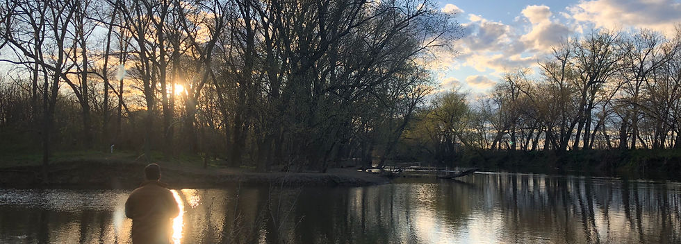
About Broad Run Farms
The Full Story
If Broad Run Farms were proposed for subdivision today, an archaeological survey would be required before construction could begin. Such a study would likely be fruitful, as the community’s land has a rich and colorful past.
Prehistoric Visitors and First Residents
Prehistoric Visitors
Beneath Broad Run Farms lies a layer of fractured shale, a natural formation that has preserved fossilized dinosaur footprints and bones.
First Residents
Native Americans lived in the Broad Run Farms area for thousands of years, with archaeological evidence showing their presence as early as 6500 B.C. The first visitors were likely hunting parties, and it is still common to find arrowheads while gardening in the community.
As European colonization approached, Native American agricultural settlements appeared along the banks of the Potomac River and on its islands. Floods, which occurred every three to four years, enriched the soil and aided farming. The Algonquian people were the primary residents when Europeans arrived, though Iroquois groups may also have passed through the area during seasonal migrations between hunting grounds.
The First Europeans
Broad Run Farms was named by the first known Europeans to explore the region. On April 17, 1699, Burr Harrison and Giles Vandercastle, deputized ambassadors to the Piscataway Indians near Point of Rocks, wrote in their journal:
“About seven or eight miles above Sugar Land, we came to a broad branch of about 50 to 60 yards wide: a still or small streeme; it took oure horses up to the Belleys, very good going in and out.”
Historians believe this description refers to the present-day Route 7 crossing, which was then a natural break in the river bluff.
The First Owners
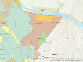
According to Loudoun County records (I-222), the original landowner of Broad Run Farms was Robert Carter Jr., who acquired the Frying Pan tract in 1772. The tract totaled 14,847 acres.
The identity of the first European resident, however, is debated. In 1649, King Charles II granted land that included Broad Run Farms to seven supporters. By 1690, the Culpeper and Fairfax families jointly owned the property and appointed agents to survey and lease the land.
For many years, Thomas Lee was thought to be the first lessee and resident, with holdings stretching from Goose Creek to the Sugarlands, including Seldon’s Island (purchased in 1825 by Wilson C.V. Seldon from Ludwell Lee, a descendant of Thomas Lee).
In the early 1980s, however, local historian Carl MacIntyre discovered a map and deed showing that John Pope was the first recorded owner in 1709. His land grant, dated Feb. 10 of that year, extended from Broad Run to the boundaries of Daniel McCarty’s tract near Sugarland Run. This grant was the earliest parcel of land located wholly in today’s Loudoun County.
In 1729, the southern portion of Broad Run Farms was granted to Robert Carter Jr. Like much of eastern Loudoun County at the time, the land was likely used for growing corn and tobacco, with enslaved people working the fields.
Image, Original Land Grants of Loudoun County depicts the Frying Pan Tract owned by Carter, Jr., Loudoun GIS

The Broad Run Bridge
The Route 7 bridge over Broad Run has a long history dating to the 1750s. Local historian Eugene Scheel described the original crossing as “too deep for ford, too narrow for ferry.” To meet travel needs, early Virginians built a bridge of log sleepers supporting wooden rafters, often without nails. When floods damaged the structure, the next traveler was expected to repair it.
George Washington is believed to have made repairs himself when he crossed the bridge in 1753 and 1754. By 1771, Loudoun County officials were allocating about $500 for reconstruction of the bridge “at the usual place,” making it one of the earliest county-maintained byways.
In 1809, the bridge became part of the Leesburg Turnpike, a 20-mile road to Dranesville funded with a $41,450 state appropriation — then the largest in Virginia’s history. By 1820, a stone bridge and tollhouse had been built at the site.
Around 1810, Levi Whaley founded a settlement called Broad Run near the bridge after purchasing 51 acres along both sides of the turnpike and Broad Run from Henry B. Lee, the last of the area’s Virginia Lees. The site included a gristmill, sawmill and post office.
Historic photos show the Broad Run Toll Bridge on Route 7 in 1953, and again in 1973 after Hurricane Agnes destroyed it. Tomas Balch Library.
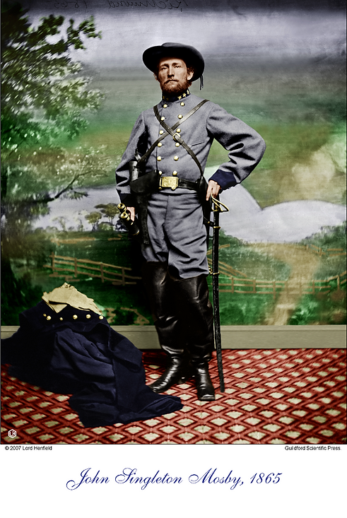
The Making of John Mosby
In the mid-1800s, most of Broad Run Farms was part of a 755-acre property known as Miskel’s Farm, located near the intersection of Broad Run Drive and Dairy Lane. A Civil War skirmish took place there on March 31, 1863, marking the rise of Confederate Capt. John Singleton Mosby.
The night before the battle, Mosby and his men camped at Miskel’s Farm, believing they were safe from attack since Union troops were 15 miles away. But at daybreak, the 1st Vermont Cavalry charged into the barnyard. Despite being outnumbered 150 to 70, Mosby’s men wielded repeating pistols and carbines, giving them an advantage over Union sabers. When the Union soldiers closed the gates behind them, their retreat turned into a rout. Mosby’s forces captured 83 prisoners and 95 horses before pulling back. His victory earned him a promotion to major.
An 1895 engraving by artist James Taylor depicts the skirmish and was published in James Williamson’s 1896 book Mosby’s Rangers.
.

Postwar Growth
Sam Jenkins, nephew of John Miskel, managed the farm in the late 1800s. In 1880, Isaac VanDeventer purchased both the Broad Run settlement and Miskel’s Farm. By the late 1870s, Broad Run had opened its first public school, a one-room frame building that stood on what is now the east side of Lakeside Drive. The school closed in 1922, and the building was later moved about a mile south to house farmhands at what was then Sterling Farm.
Until the 1920s, Broad Run was also known as the best site for harvesting winter ice, with the river’s depth ideal for cutting three-foot blocks.
During Prohibition from World War I through the 1930s, Broad Run Farms gained a reputation as a center for bootleg whiskey production. The stone house near the Broad Run crossing and VanDeventer’s Island were known for large stills, with smaller operations scattered throughout the area. After Prohibition ended, the Toll House became a popular destination for its gardens and scenic river views.
Image: Broad Run Toll Bridge at Rt.7 from 1953, Loudoun Planning Commission
Broad Run Farms Becomes a Neighborhood
In 1950, Robert and Barbara Young purchased the 706-acre Miskel Farm. After briefly running it as a dairy farm, Robert Young subdivided the land in 1951 and named the community Broad Run Farms. It was the first subdivision in Loudoun County to meet modern standards. Unlike earlier subdivisions such as Fairview and Ridgeview, the lots in Broad Run Farms were large enough that buyers did not need to purchase two adjoining parcels to build a home.
Young was required to construct 40-foot-wide paved roads, and he included common access to the Potomac River and Broad Run — an innovative feature at the time. Lots sold quickly, with half- to one-acre parcels priced around $1,200 and 10-acre riverside lots selling for about $10,000.
By 1958, every lot was sold, some directly by Young, who was known to park a trailer along Route 7 to attract prospective buyers.
A Prominent Neighborhood
The first resident of Broad Run Farms was Gen. William Lafayette Fagg, who moved in May 1952. Fagg once served as provost marshal of the U.S. Air Force. Another notable resident was Sen. Everett Dirksen, who lived with his wife at “Heart’s Desire,” their home on the Potomac along Young Cliff’s Road in the late 1950s. In 1959, while residing there, Dirksen became Senate minority leader.
For a time, the marigold was considered the community’s official flower. Dirksen, an avid horticulturalist, grew large numbers of marigolds at his home, even planting them before his house was complete while living in a temporary trailer.
The Broad Run Farms Civic Association
In 1950, Robert and Barbara Young purchased the land that became Broad Run Farms and subdivided it the following year. In 1955, they filed a deed granting homeowners use of two community recreation areas — one along Broad Run and the other on the Potomac River.
After Robert Young’s death in 1984, the properties were deeded to the Broad Run Farms Civic Association. A final deed was recorded in 1985 after a barn was discovered to have been mistakenly built on the wrong property and a land swap was completed with the river lot.
Aerial photos from 1957 show that the neighborhood and its two recreation lots were largely open fields. By the late 1970s, the areas had become overgrown until local Boy Scouts cleared brush and built picnic tables as part of an Eagle Scout project in 1977. In the years since, residents have completed multiple improvement projects, transforming the properties into the well-maintained parks the community enjoys today.
Galilee United Methodist Church
The only nonresidential building ever constructed in Broad Run Farms is Galilee United Methodist Church. Built in 1965, the church’s distinctive wavy roofline, with 14 crests, was designed to evoke the surface of the adjacent Lake Galilee.
When Robert Young first arrived in 1950, the lake did not exist. The area was then a swampy lowland with a few small homes. In 1952, the installation of a six-inch sanitary sewer line created the lake. Ownership of the water surface was granted in common to the landowners surrounding it, although individual property lines remain beneath the water.

Community Today
The Broad Run Farms Civic Association continues to preserve the neighborhood’s character and green space. Monthly meetings are held on the second Wednesday of each month at 7 p.m. at Galilee United Methodist Church, or at the Pavilion. Check back here for updates. All residents are welcome to attend. Only paid members may vote on association matters.